

The Jordan River Loop is a backpacking trail that is normally completed in two days. I usually have seen the loop listed as 18.5 miles. I tracked it as closer to 20 from the hiker parking lot to the actual campsites. It may actually be a little longer than that with the detour at the beaver dam (more on that later). Okay, let’s break it down.
What: Jordan River Loop, a 20-ish mile loop
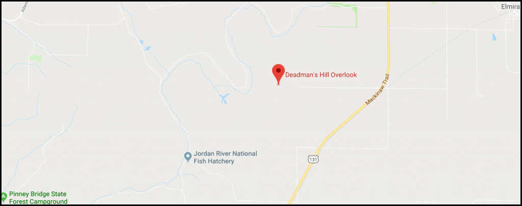
Location: Starting at Deadman’s Hill, 17 miles West of Gaylord
Difficulty: Moderate
Camping: Backcountry camping is NOT allowed. Camping is to be done at the Pinney Bridge State Forest Campground.
We had a group of 7, members of the outdoor group SOLAR and completed this hike from Saturday, June 30 to Sunday, July 1. The trail starts at Deadman’s Hill Overlook near Elmira, MI. There is a parking area for overnight hikers, which appeared to be free of charge.
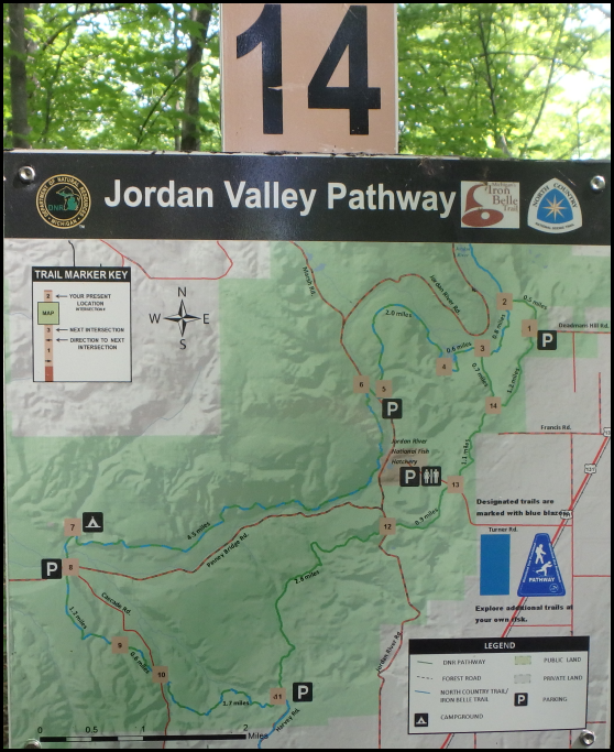
We opted to complete the Southern Portion of the loop first, as it was the longer portion (I clocked it at 11 miles to our campsite). To do that, from the top of the overlook start hiking south along the trail.
I struggled with this portion of the trail. I consider myself a strong hiker, but I am affected by heat and become uncomfortable in anything over 85 degrees Fahrenheit. We started hiking close to 11 am and the peak temperature for the day was 100 degrees with the “feels like temperature” at 124. The majority of the hike was completed in the upper 90’s. Luckily, the trail is mostly wooded with canopy coverage and there are multiple places to replenish your water supply if you are carrying a filter (which you should be).
I checked average temperatures for nearby Gaylord MI and the highs are normally 74 in June and 79 in July, so these upper 90’s days were not normal.
The southern section of the trail is well maintained. The path is easy to follow and there are bridges over any significant water crossings.

Normally I like being able to backcountry camp on backpacking trips, but I found Pinney Bridge Campground to be very pleasant. It is a large area with sites split up to not be on top of each other. It has a hand pump for water, fire rings, and vault toilets. The fee is $15 dollars a night (at the time of this writing) and I found that to be very acceptable especially when split with friends. There is parking close to Pinney Bridge, but many people hike in from Deadman’s Hill.
We completed the Northern section of the hike on July 1. We started early, to avoid hiking in the heat of the day. Temperatures only got up to the upper 90’s (heh, only). I did better this day, as the group cranked out 4.8 miles before 10 am and the day really heated up.
I clocked the north side of the trail to be about 9 miles from our campsite to the Deadman’s Hill parking lot. Most of it is well maintained, but there are some sections that were not. There were several sections of very close vegetation growth and several sections where the trail was muddy beyond the provided boardwalks. I was surprised at how muddy sections of the trail were considering how dry and hot it had been before and during the time of our hike.
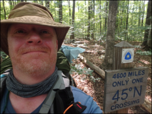
The northern section crosses the 45th parallel and the North Country Trail has a cool sign that makes for a photo opportunity. Sorry, the picture is of me and not one of the more photogenic members of the group.
There is a bridge out by a beaver dam on this section of the hike.

People have placed boards to the left of the damn to get across this section. They were not stable and I got two wet boots during my crossing. After reaching the other side, we learned that there is actually a detour going around the pond to the right. The detour is probably the safer and more environmentally friendly way to go. I am not sure what mileage it would have added to the hike.
Shortly after where the bridge is out is where the trail was at its muddiest and most overgrown section. I do not know if the detour would also have avoided this section, but I believe that it would not have.

After coming through a portion tangled with vegetation, I momentarily lost the trail. I took three or four steps before realizing that I was not on the path and stopped to look for the path or for a blue blaze. As I did this, I saw motion and looked over just in time to see a small black bear run into the woods! It was exciting to see my first bear in the woods, but it also reminded me to follow proper techniques such as bear-bagging and hiking with a group.
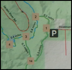
When we hit mile marker 3, we were faced with a decision. We could go from markers 3 to 14 to 1, which would be 1.9 miles. Or we could go from 3 to 2 to 1, which would be 1.3 miles but be faced with the last .5 miles going up a significant hill. (Basically, the choice was shorter with a big hill or longer with less of a grade). We chose to do the hill.
The hill was no joke, with the temperature in the mid 90’s by the time we reached it. The hill is very misleading in that you cannot see the top. It twists and turns and you really do not know when you are going to be done with it. I started off taking the hill with strong, long strides the way I attempt most hills; but I quickly became tired and stopped for a break. I tried this twice more before I determined I could not do the hill this way. I settled for a slow, but steady pace up the hill letting my body determine the speed based on my pulse rate. With the heat of the day, that pace was very slow. I felt like I was taking baby steps climbing that hill. The pace did allow me to look around more and enjoy the scenery of my last minutes of the trail.
Conclusions: There are several sections of this trail that are in wooded paths, members of the group found them to be visually boring. I supposed if compared to the vistas at Pictured Rocks or even the riverside of the Manistee River loop, some sections could be considered not as optically pleasing; but I personally did not mind them.
From a planning perspective, this trip is great. Deadman’s Hill can be chosen as a destination using Google Maps and there is a sign for it from 131, so finding the starting location is easy. The Pinney Bridge Campground is actually quite nice and knowing the mileage to it helps to plan starting times.
Bugs were not terrible, there were not many mosquitoes and I saw zero ticks. The worst bugs were tiny little flies that seemed to like my eyes, nose, and mouth and black flies that can have a painful “bite”, but neither was overwhelming.
The trail was mostly well maintained, well-marked, and easy to follow. There are several decent climbs with the biggest hill being avoidable. Our hike was challenging with the extreme heat (20 degrees above the norm). If the temperature had been more consistent with normal for the time, I would have called the difficulty moderate. The south side, at 11 miles, can be a long day; make sure your conditioning is up for it.
Overall, I like the trial. As a hiker, I found it pleasant and as a planner, I found it one of the easiest to set up. I would recommend this trip.